|
Notes: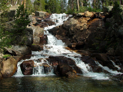
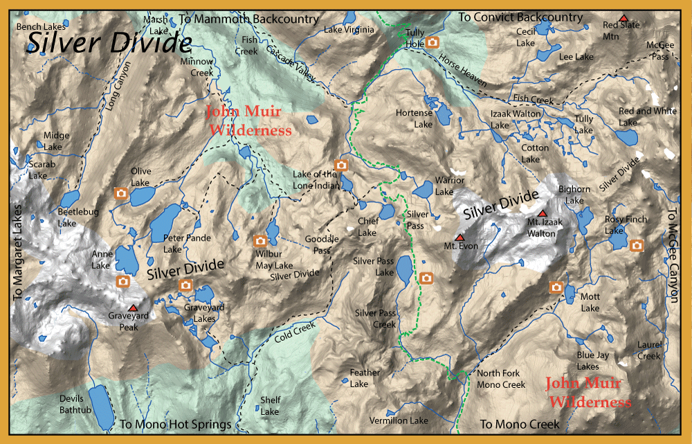
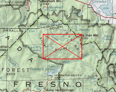
Silver Divide basically divides watersheds of the Middle Fork and South Fork San Joaquin River. North of the Silver Divide, streams and outflows of lakes flow into Fish Creek. This is the dominant stream flowing through the Cascade Valley.
Fish Creek begins at the headwaters of Red and White Lake below McGee Pass. It flows
through Cascade Valley on the way to the Middle Fork of the San Joaquin River for about 19 miles. This area is also known as
the northern portion of the John Muir Wilderness. The headwaters consists of a number of pocket pools
containing Brookies, Rainbows
and Rainbow-Golden hybrids in the 6-8" range at about 10,350 feet. The freestone creek follows the
Pacific Crest Trail for about a mile and builds up flow from additional water off Lee Lake and other
tributaries. The first meadow is Horse Heaven with large shallow pools. Another lush meadow area further
downstream is Tully Hole (elevation 9,600 feet), a good location for dry flies. This area has 6-10 inch
brookies as well as some Rainbows and Rainbow-Golden hybrids. Below Tully Hole, the creek becomes a classic
Sierran stream with runs, pockets, and pools and drops into Cascade Valley. The trout tend to get larger
in size in the 10-12 inch with more Rainbows and Rainbow-Golden hybrids than brookies. Cascade Valley
basically starts at the Indian Lakes below Silver Pass. Fish Creek has about 5-6 waterfalls as it passes
through Cascade Valley. Between waterfalls, the creek will be a freestone type creek with pools, runs,
and pocket waters. There will be some portions within small meadows that will allow the creek to slowly
meander. The water is very clear and the fish tend to get spooky. Tackle suggestions are a 8.5 foot 3 wt. rod
with a 7.5 foot 6X leader. Small drys work well drifting within the foam lines. Try Wulffs, Humpies, Elk Hair
Caddis, Hoppers and Ant Patterns. Nymph patterns also work well, particularly if the creek becomes discolored
from afternoon thundershowers. Try Pheasant Tail Nymphs, Prince Nymphs, and Copper Johns.
From the Lake Mary Trailhead, you can access the following lakes taking trail 27E12 below Purple Lake to Fish Creek and crossing the creek and taking 27E15 down Long Canyon:
Beetlebug Lake: Beetlebug Lake is about 4.6 miles on the trail up Long Canyon at an elevation of 9,700 feet. It consists of Brookies.
Midge & Scarab Lake: These lakes are at 10,600 feet and accessed from Long Canyon. Each contains Brookies. Difficult access, must follow the stream outflow off-trail.
From the Lake Mary Trailhead, you can access the following lakes taking trail 27E12 below Purple Lake to Fish Creek and crossing the creek and taking 27E02 southwest:
Grassy Lake: (20 acres) at an elevation of 9,500 feet. On the Minnow Creek Trail from the western edge of Lone Indian Lake
for about 2 miles. Contains Rainbows.
Peter Pande Lake: (60 acres) at an elevation of 10,000 feet with 1.5 miles of shoreline. Consists of Rainbows in the 12-13 inch
class and Brookies in the 8-10 inch class. Take the Minnow Creek Trail from Lake of Lone Indian's western shore about
3.5 miles. The lake is planted with rainbows periodically. Two cascading waterfalls flow into the lake from Anne Lake. Fish these inlets.
The north side of the lake is the most accessible with a trail that follows the shoreline.
Anne Lake: (50 acres) at an elevation of 10,280 feet with 1.7 miles of shoreline. Consists of Rainbows in the 12-13 inch
class. Take the Minnow Creek Trail from Lake of Lone Indian's western shore about
3.5 miles to Peter Pande Lake. Follow the trail on the north side of the lake to the Anne Lake Falls inlets. Follow the creek
about .25 miles to the lake. Fish the outlet channels of the lake. Also try the numerous points off the coves that surround the
lake. Just north of the outlet is 3 acre Minnie Lake. This lake also contains Rainbows.
Olive Lake: (50 acres) at an elevation of 9,700 feet. Contains Rainbows mostly in the 8-9 inch class. Fish the
drop-off along the northern shoreline. Can reach the lake by going off-trail from Minnie Lake to the northwest. From a small pond,
follow the outlet stream for .5 miles to the lake. Olive can also be reached by the trail from Grassy lake.
From the Lake Mary Traihead or the McGee Pass Trailhead proceeding onto the PCT/JMT at Tully Hole, going south you can reach:
Chief Lake, Papoose Lake, Lake of Lone Indian: (20 acres, 5 acres, 20 acres, respectively) at an elevation of 10,500 feet.
Each lake consists of Brookies in the 6-8 inch class. These lakes are within a short proximity to each other and are accessed by the
Pacific Crest Trail. The lakes are situated at the head of Cascade Valley below Silver Pass. About 7 hour pack from McGee Pack
Station.
Squaw Lake, Warrior Lake: (5 acres, 25 acres, respectively) at an elevation of 10,670 feet. Consists of Brookies in the 6-8 inch
class and some small Rainbows.
Wilbur May Lake: (40 acres) at an elevation of 9,980 feet. Consists of Rainbows in the 12-13 inch class and Brookies in the
8-10 inch class. Take the Minnow Creek Trail from Lake of Lone Indian's western shore about 1.25 miles. A side trail of .4 miles
going south will go to Wilbur May Lake. The lake is planted with rainbows periodically. Best areas are the creek inlets.
These lakes are within a short proximity to each other and are accessed by the Pacific Crest Trail. About 7 hour pack from
McGee Pack Station.
Izaak Walton Lake: (8 acres) at an elevation of 10,300 feet. Consists of Golden Trout. Take the McGee Pass Trail to where it meets Fish Creek. Walk up Fish Creek, no trail, from there.
Lower & Upper Hortense Lakes: (12 and 24 acres, respectively) at an elevation of 10,400 feet. Consists of Brookies. Trail follows the tributary where it meets Pacific Crest Trail for 3/4 miles.
Lee Lake: (18 acres) at an elevation of 10,800 feet. Had Consisted of Rainbows, now managed as "Fishless". Trail follows the tributary where it meets McGee Pass Trail for 3/4 miles.
Cecil Lake: (18 acres) at an elevation of 10,900 feet. Consists of Rainbows. Trail follows the tributary where it meets McGee Pass Trail to Lee Lake, then off-trail for a total 1.1 miles.
Tully Lake: (8 acres) at an elevation of 10,475 feet. Consists of Brookies. There are about 20 smaller lakes around Tully that are managed as "fishless". Trail from McGee Pass trail about 1/3 mile.
Red & White Mtn. Lake: (30 acres) at an elevation of 11,100 feet. Consists of Rainbows. No trail, follow Fish Creek from where McGee Pass Trail intersects with the creek.
From the West Side Sierra at Thomas Edison Lake, you can reach:
Devils Bathtub: (65 acres) at an elevation of 9,127 feet. Consists of Rainbows and Brookies. A 5 mile hike from Edison Lake trailhead.
Graveyard Lakes: Contains numerous small lakes but basically has a large lower lake and a larger upper lake. The lower lake is at 10,000 feet and contains Brookies. The larger upper lake is at 10,400 feet and contain Rainbows. An 8 mile hike from the Edison Lake trailhead.
Silver Pass Lake: (50 acres) at 10,360 feet elevation. Contains Goldens, 6-8 inches. About 11 miles from the Edison Lake trailhead or 7 miles from the end of Edison Lake taking the ferry.
Mott Lake: (17 acres) at 10,040 feet elevation. Contains Rainbows. About 11 miles from the Edison Lake trailhead or 7 miles from the end of Edison Lake taking the ferry.
Rosy Finch Lake: (24 acres) at 10,800 feet elevation. Contains Rainbows. Going off-trail following the inlet stream for 3/4 mile from Mott Lake take the eastern fork for 1/4 mile.
Bighorn Lake: (25 acres) at 10,525 feet elevation. Contains Goldens. Going off-trail following the inlet stream for 3/4 mile from Mott Lake take the western fork for 1/4 mile.
|
| Fishing Regulations (Effective March 1st, 2021)
Fish Creek:
From the last Saturday in April through November 15, 5 trout daily bag limit, 10 trout in possession; and, from November 16 through the Friday preceding the last Saturday in April, 0 trout bag limit, artificial lures with barbless hooks only and trout must be released unharmed and not removed from the water.
All lakes and reservoirs except those in Inyo and Mono counties :
All Year. No restrictions. 5 trout per day. 10 trout in possession.
All other creeks and tributaries:
From the last Saturday in April through November 15, 5 trout daily bag limit, 10 trout in possession; and, from November 16 through the Friday preceding the last Saturday in April, 0 trout bag limit, artificial lures with barbless hooks only and trout must be released unharmed and not removed from the water.
|