 |
||
|
Suggested Flies for NF Tule River area: Southern Sierra Hatch Selection | ||
|
Other Local Favorites: Dry Flies: |
Nymph Flies: |
|
|
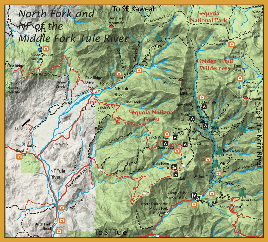
Directions:  To get to the North Fork of the MF Tule River, take Highway 190 8 miles west of Porterville to the Tule River Ranger Station in Springville. Drive 4 miles northeast to Balch Park Road and turn left to Mountain Home State Forest. Go 4 miles to Bear Creek Road and turn right. Drive along Bear Creek road for 23 miles to a Y intersection. The headquarters of Mountain Home State Forest is 0.2 miles to the left. Take the right fork off the Y onto Summit Road. 5 miles on Summit will bring you to Shake Camp trailhead which provides access on the River Trail. Moses Gulch Trailhead provides access to the Golden Trout Wilderness Lakes of Maggie, Frog, and Twin via the Griswold/Summit Trail. | ||
|
| ||
|
Notes: | ||
Fishing Regulations (Effective March 1st, 2021)Tule River, North Fork, only in the North Fork Tule River and all its forks and tributaries above the confluence with Pine Creek (about 50 yards upstream from the Blue Ridge road bridge, about 12-1/4 miles north of Springville).: All year. Only artificial flies or lures may be used. 2 Trout. All remaining portions of the Tule River and tributaries: From the last Saturday in April through November 15, 5 trout daily bag limit, 10 trout in possession; and, from November 16 through the Friday preceding the last Saturday in April, 0 trout bag limit, artificial lures with barbless hooks only and trout must be released unharmed and not removed from the water. Other Rivers and Streams: From the last Saturday in April through November 15, 5 trout daily bag limit, 10 trout in possession; and, from November 16 through the Friday preceding the last Saturday in April, 0 trout bag limit, artificial lures with barbless hooks only and trout must be released unharmed and not removed from the water. All other Lakes: Open all year. No restrictions. 5 trout per day. 10 trout in possession.
| ||