|
Notes: 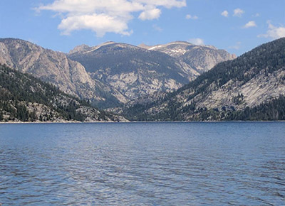
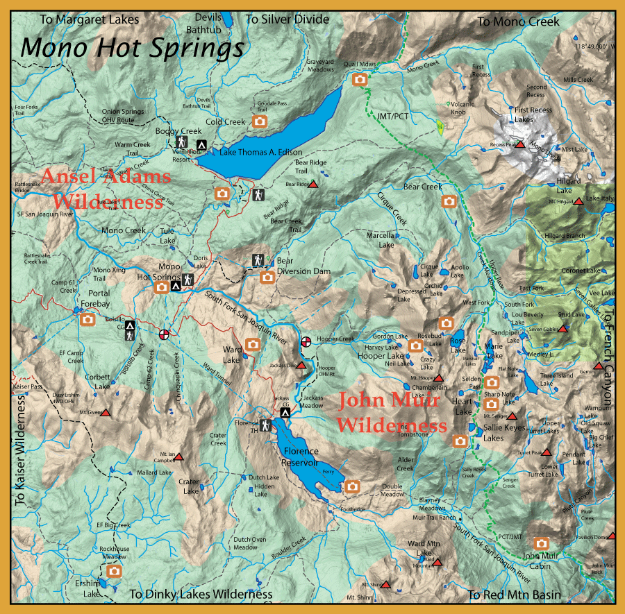
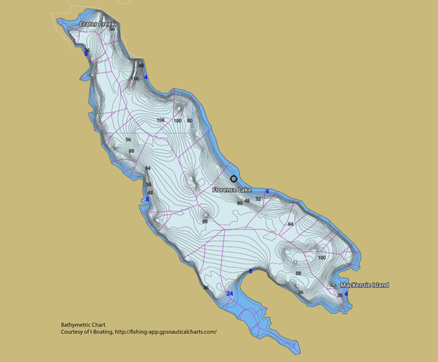
The Mono Hot Spring area is accessed by a long and windy Kaiser Pass Road out of Huntington Reservoir. The area was initially developed for water and power in the early 1900's with the damming of Big Creek creating Huntington Reservoir in 1912 and damming the SF San Joaquin to create Florence Lake in 1926. In 1936, the Mono Hot Springs Resort was completed close to the site where the CCC built concrete lined tubs for the hot springs in 1934. This resort features a cafe, cabins, campgrounds, Hot Spring pools with Massage Therapy, Post Office, and store. The two main reservoirs, Edison and Florence, and the SF San Joaquin near the MHS resort get lots of planted trout throughout the season. The lakes are generally trolled with hardware and the river is heavily fished by baiters. However, there are ample areas for good fly fishing away from the crowds. Above Florence Reservoir, the SF San Joaquin is a designated Wild Trout stream and has many lakes and creeks within it's watershed for excellent fishing. Bear Creek is also an excellent area for fly fishing with its headwaters containing Golden Trout. The two main reservoirs, Florence and Edison, can also provide excellent fly fishing at the inlets, particularly in the Fall when the Browns stage to migrate. Along Kaiser Pass Road, you can stop at Portal Forebay. The Forebay is about 20 acres and is planted with trout. It makes a good spot to float tube and pull a streamer. Another good location to float tube is Ward Lake, just 2 miles from Florence Reservoir. Ward Lake covers about 6 acres and contains both Rainbows and Browns. The best areas are the northern shores where lily pads provide cover for the trout.The season is Last Saturday of April to Nov.15th. There is a 5 trout limit but the Sierra National Forest allows an additional 10 Brookies if under 10 inches.
Edison Lake is a large recreational lake covering 1800 acres, 11 miles of shoreline, and was first constructed in 1928 at 7,650 feet by a rock-filled dam over Mono Creek. A concrete dam was built in 1954 which greatly increased the size of the lake. The lake is accessible after snow melt usually around Memorial Day. It offers
campsites, resort, boat ramps and a trailhead to Pacific Crest Trail. A ferry service is available to get to the other side from the Vermillion Resort. Edison
contains mostly rainbows in the 10-12 inch class with some large Browns and brookies. The lake record for Browns is 23 Lbs. 4 oz. Some of these Browns
will get up to 18 inches and will move into the creeks during the Fall to spawn. During the first week of June, a Carpenter Ant
hatch occurs. The inlet of Mono Creek and Cold Creek are some of the better sites to fish by float tube or boat and along the northern shore. Spring and Fall are the best times to fish this lake as the fish move into the mid- channel by Summer.
The trail along the northern shoreline has an offshoot that runs along Cold Creek. Cold Creek consists of Brookies and Rainbows.
A the east end of Edison Lake, you can follow Mono Creek to Mono Pass and Little Lakes Valley behind Rock Creek Lake. Mono
Creek, depending upon elevation, is one of the few streams within the Sierras that has the Sierra Grand Slam of Rainbows, Brookies,
Browns, and Goldens.
The main fork of Mono Creek just above Edison Lake has Browns in the 8-10 inch class with some up to 12". As you go further
upstream, you will encounter more Rainbows.
The headwaters of Bear Creek are within the John Muir Wilderness. Three forks originate from more than 30 lakes, creating a West, East, and South Fork. These three forks converge in Upper Bear Creek Meadow. This area consists of Rainbows, Goldens, and Brookies mostly in the 10 inch class. The streams are generally pocket and pool waters with some high elevation meadow streams and lakes filled with Goldens. Goldens were first stocked just below Marie Lake within the West Fork. The population did exceedling well and thrived to the main branch of Bear Creek. Subsequently, the drainage lakes and the other two forks were also stocked from these Golden populations to create a Golden Trout drainage within Bear Creek. The John Muir/Pacific Crest Trail goes through the heart of this area and the proximity of both Edison and Florence make this region a good entrance/exit area for backpacking, leaving a car at either lake and providing for shuttle service. The total trek between the two lakes is about 25 miles going over 10,800 foot Selden Pass. Below Upper Bear Creek Meadow, Bear Creek has a substantial flow dropping from 10,300' to 7,300' over a 15 mile stretch. At the Bear Diversion Dam. most of the water is piped to Huntington Reservoir.
From the Bear Diversion Dam TH, it is about a 6.5 mile hike to reach the PCT following Bear Creek with Rainbows and Brookies, mostly in the 8-10 inch size.
Taking the spur trail at Hilgard Branch Bear Creek, the trail follows the Hilgard Branch up to it's headwaters of Lake Italy. There is about 4.5 miles of stream, mostly consisting of Goldens in the 8 inch class, going from 9400 to 11,130 feet elevation. Lake Italy: Consists of Goldens. Elevation is 11,130 feet. About 12.5 miles from the trailhead.
Continuing on the PCT another spur trail is at the East Fork Bear Creek which consists of Goldens. The East Fork starts 10 miles from the trailhead at about 9800 feet elevation and drains 8 major lakes making it the largest of the three forks. About 1.75 miles upstream from the confluence is the first lake of Seven Gables Lakes at 10,700 feet. Seven Gables Lakes: A series of about 10 lakes each containing Goldens. The lakes extend for about 2 miles and go from 10,700 to 11,000 feet. First lake is about 12 miles from trailhead. Vee Lake: (55 acres) This lake is 13 miles from trailhead at 11,150 feet elevation. Consists of Goldens, some indicate up to 18 inches.
The South Fork Bear Creek can be accessed by a spur trail about 1 mile from the confluence with the East Fork on the PCT. The South Fork is exclusively Goldens with larger Goldens in the 17-18 inch class in the upper lakes of Sandpiper Lake and Three Island Lake. Continuing on the PCT past the spur trail will take you along the West Fork Bear Creek which has not only Goldens but also Brookies. The West Fork originates from three lakes, Marie Lake, Rose Lake, and Marshall Lakes. Marie Lake: (92 acres). At an elevation of 10,551 feet. Marie Lake was known for large Goldens up to 18 inches, currently reported to have excusively Brookies in the 12-15 inch range. Rose Lake: (82 acres). At an elevation of 10,495 feet. Contains Goldens, 10-12 inches
From the Jackass Meadow Campground going north, you can access:
South Fork San Joaquin River: From Florence lake to Mono Hot Springs, the SF San Joaquin is about 7 miles long with a 700 foot drop in elevation to 6500 feet. This is an excellent area to flyfish. It is a tail-water fishery with even flows coming out of Florence Lake. The stream is slow moving through Jackass Meadow and then becomes a typical run-pool-riffle stream onto Mono Hot Springs. Consists of Rainbows and Browns, some of large size since they get washed downstream from Florence during water releases. Hooper Creek: Consists of Goldens. About 2.6 miles from the campground. A 2.5 mile stretch of stream going from 7000 to 9900 feet elevation just below Gordon Lake. There is no trail so you have to follow the stream. Gordon Lake: Elevation is 9,900 feet. Consists of Goldens. Just over 5 miles from the trailhead. No trail, follow Hooper Creek. Harvey Lake: Elevation is 10,150 feet. Consists of Goldens. About 5.4 miles from trailhead. No trail, follow Hooper Creek. Hooper Lake: Elevation is 10,500 feet. Consists of Goldens. About 6.1 miles from the trailhead. No trail, follow Hooper Creek. Neil Lake: Elevation 10,600 feet. Consists of Goldens. About 6.3 miles from trailhead. No trail, follow Hooper Creek. Chamberlain Lake Elevation is 10,000. Consists of Goldens. No trail and it's too difficult to get there.
From Florence Lake TH you can reach the following waters:
SF San Joaquin River: It's about a 3 mile hike into Blayney Meadows from the southern end of Florence Lake where the ferry drops you off. Blayney Meadow is about 2 miles long and consists of a store at Muir Trail Ranch, Campgrounds, Hot Springs, and a meandering River through a meadow with good size Browns up to 14 inches. Beyond the meadow, the river becomes a typical riffle, run, and pool stream with both Browns and Rainbows in the 10-12 inch class. A trail follows the river into Kings Canyon National Park. The park is about 4 miles upstream from Muir Trail Ranch. The Piute Trail going to North Lake spurs off the PCT/JMT right at the Kings Canyon National Park boundary and follows Piute Creek consisting of Goldens. Going off-trail from Piute Creek you can reach the following lakes: Big Chief Lake: Consists of Goldens. Elevation is 10,875 feet. Old Squaw Lake: Consists of Goldens. Elevation is 11,050 feet.Wampum Lake: Consists of Goldens. Elevation is 11,500 feet.
Turret Creek: Consists of Goldens.
Lower Turret Lake: Consists of Goldens. Elevation is 10,750 feet.
A half mile from the John Muir Ranch, a spur trail will connect to the PCT/JMT going north. Along this route you will encounter the following waters.
Senger Creek: About 2.2 miles along the PCT from Muir Trail Ranch, the trail intersects Senger Creek at 9,750 feet. Working the creek upstream you will encounter Goldens in the 5-8 inch class. There is about 1 mile of stream until you hit it's first headwater lake at 10,400 feet. The creek is named for Joachim Senger, one of the four original founders of the Sierra Club. Sallie Keyes Creek: The PCT reaches Sallie Keyes Creek just below one of it's lakes. It is about 3.5 miles from the Muir Trail Ranch with a 2,500 foot gain to 10,150 feet. The creek consists of Goldens somewhat larger than Senger's, in the 8-10 inch class. There is about 1/2 mile of creek both above and below the Sallie Keyes Lakes. Sallie Keyes Lakes: Sallie Keyes Lakes were originally planted with Goldens from Golden Trout Creek in 1914. The latest planting occurred in 1985. The fish are able to sustain themselves due to the spawning habitats of the creek. Most of the Goldens are in the 8-10 inch class with some up to 12 inches. There are three lakes at 10,200 feet, about 4 miles from Muir Trail Ranch. Heart Lake: This lake was also planted with Goldens in 1914. Most of the Goldens are in the 8-10 inch class. About 5 miles from Muir Trail Ranch at an elevation of 10,500 feet.

|
| Fishing Regulations (Effective March 1st, 2021)
Mono Creek upstream of the confluence with the North Fork Mono Creek.:
From the last Saturday in April through November 15, 5 trout daily bag limit, 10 trout in possession; and, from November 16 through the Friday preceding the last Saturday in April, 0 trout bag limit, artificial lures with barbless hooks only and trout must be released unharmed and not removed from the water.
Mono Creek and tributaries (Fresno Co.) from Edison Lake upstream to the confluence with the North Fork Mono Creek.:
Saturday preceding Memorial Day through September 30th. No restrictions. 5 trout per day. To protect spawning browns.
Mono Creek below Edison Lake:
From the last Saturday in April through November 15, 5 trout daily bag limit, 10 trout in possession; and, from November 16 through the Friday preceding the last Saturday in April, 0 trout bag limit, artificial lures with barbless hooks only and trout must be released unharmed and not removed from the water.
Boggy Creek (Fresno Co.) and tributaries (tributary to Thomas Edison Lake).:
Saturday preceding Memorial Day through September 30th. No restrictions. 5 trout per day.
Cold Creek (Fresno Co.) and tributaries (tributary to Thomas Edison Lake).:
Saturday preceding Memorial Day through September 30th. No restrictions. 5 trout per day.
Other Rivers and Streams:
From the last Saturday in April through November 15, 5 trout daily bag limit, 10 trout in possession; and, from November 16 through the Friday preceding the last Saturday in April, 0 trout bag limit, artificial lures with barbless hooks only and trout must be released unharmed and not removed from the water.
Lakes within this area:
Open all year. No restrictions. 5 trout per day. 10 trout in possession.
|